- Home
- Entire Malaysia
- Melaka▼
- Sports & Outdoors
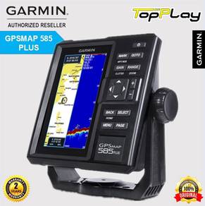
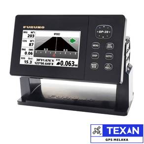
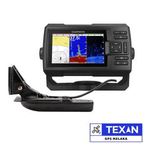
- Garmin GPSMAP 585 Plus GPS Chartplotter Fishfinder
Garmin GPSMAP 585 Plus GPS Chartplotter Fishfinder
List-ID: 5325677929 May 10:55


Description
Specification
- Find fishing spot, Catch fish with the Power of Garmin CHIRP
Multi language support: English, Simplified Chinese, Traditional Chinese, Japanese, Korean, Indonesia Bahasa, Malaysia Bahasa, Vietnamese, Burmese, Thai.
Available in 6-inch WVGA color, portrait mode display. Offers a key interface with dedicated buttons.
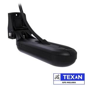
CHIRP sonar sends a continuous sweep of frequencies ranging from low to high. CHIRP sonar is able to create crisper fish arches with better target separation.
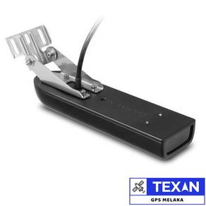
Built-in 600 W (RMS) CHIRP traditional sonar and CHIRP ClearVu scanning sonar gives a clearer picture of what is below the boat as a photographic image with representation of objects, structure and fish.
Compatible with GPS, GLONASS and BeiDou powerful positioning systems what quick and easy to drop up to 12,000 accurate waypoints let you find your way back to your secret fishing hot spots.
Free, easy-to-use Quickdraw Contours software instantly creates personalized HD fishing maps is included.
GPSMAP 585 Plus supports typical NMEA0183 and RS422 communication within 3rd party sensors and accessories.
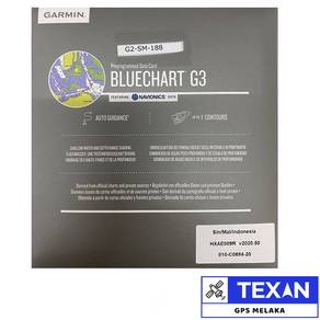
2 standard SD card slots provide expandable memory for accessory map purchases such as LakeV HD Ultra maps and BlueChart g2 Vision charts
The all-new GPSMAP 585 Plus chart plotter / sonar combo is available in 6-inch display. GPSMAP 585 Plus is offered a worldwide basemap and support all Garmin marine charts also with Asian multi language support and developed the target for semi-commercial fishing market. GPSMAP 585 Plus gives you high wide CHIRP sonar and CHIRP ClearV scanning sonar capabilities which shows crisp fish arches with excellent target separation and provides clear images of structure below the boat. Supporting GPS, GPS GLONASS, GPS BEIDOU 3 kind of positioning modes. New Garmin Quickdraw Contours software included lets you create your own maps, with up to 1-foot contour lines, on any body of water.
The Power of Garmin CHIRP
The built-in sonar capabilities of GPSMAP 585 Plus includes CHIRP sonar, the most sophisticated sonar technology available for the fishing and boating public. CHIRP sonar provides amazingly clear target separation and definition because it puts even more energy onto the target than traditional sonar. It also includes sonar-recording capability that coordinates the timing of the sonar return with your boat position and saves digital information for playback on a computer using HomePort planning software. Use the user data sharing cable to share waypoints and routes between multiple devices.
Clearest Scanning Sonar on the Water
Garmin CHIRP ClearV scanning sonar gives you a nearly photographic image down below your boat. Traditional Garmin HD-ID sonar and ClearV scanning sonar are combined into 1 transducer.
With the Best Maps on the Water Supporting
Two standard SD card slots provide expandable memory for accessory map purchases such as BlueChart g2, BlueChart g2 Vision. The BlueChart g2 Vision provide exclusive Garmin Auto Guidance, a technology that directs you to your hot spots. Based on your boat's specifications, Auto Guidance instantly creates a visual path you can follow to avoid shallow water and other charted obstructions.
Quickdraw Contours: Create Your Own HD Maps
Quickdraw Contours is a free, easy-to-use software feature already installed on your GPSMAP 585 Plus. It instantly creates your own personalized HD fishing maps on screen with 1-foot contours. Tailor the maps as needed; you own them. Keep the data for yourself or share it with Garmin or your friends. No special survey expertise is required. You just fish while Quickdraw Contours creates maps. There's no waiting around or sending your files away like other mapping software requires your results to appear instantly.
Compatible with GPS, GLONASS and BeiDou
With multi positioning modes supports GPS, GLONASS and BeiDou three powerful systems. It is quick and easy to drop up to 12,000 accurate waypoints and find your way back to your secret fishing hot spots. Huge capacity memory to help fishermen record danger spot (Mark) and the destination (Waypoint).
AIS Radar Support
Show you the detailed AIS Radar view and AIS list on the same page. Move the cursor and review particular items on the radar view to see the detailed information of highlighted vessel. Drop VRM/EBL and measure distance on the AIS Radar view window and to focus an AIS vessel through the AIS list to see the detail of it.
What is in the box:
GPSMAP 585 Plus with worldwide basemap
Transom mount transducer
Memory card with G2 blue chart maps
Power/data cable
Bail mount
Hardware
Documentation
1 year warranty
Texan Telecommunications
G1, Block Mawar 1, Jalan Murni 2, Taman Malim Jaya, 75250, Melaka, Malaysia.
Tel:
H/P: (WhatsApp)
Email:
Website: www.texantel.com.my
GPS Coordinate: N2 14.139 E102 13.944
Mudah Safety Tip
Reminder! Our staff will NEVER reach out to you through other platforms or channels outside of Mudah.my. Find out more safety tips in MudahSafety!
Do you find this ad suspicious or inappropriate?
Report this ad (List-ID: 53256779)Is this your ad? Manage it using these links.
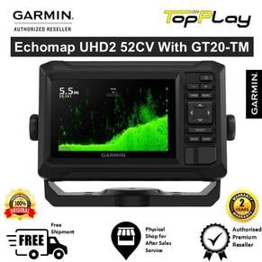
You May Also Like

Price
RM 2,899
Location
Melaka - Melaka Tengah
Condition
New
Shortlist, compare, decide — faster on the app.
Scan QR to Download App


4.7
200K+ reviews
Company
Joined since: Sep 2009
Share this ad